


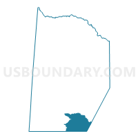
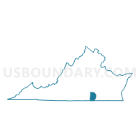
Dromgoole Voting District, Brunswick County, Virginia
About
Outline

Summary
| Unique Area Identifier | 681197 |
| Name | Dromgoole Voting District |
| County | Brunswick County |
| State | Virginia |
| Area (square miles) | 24.82 |
| Land Area (square miles) | 24.06 |
| Water Area (square miles) | 0.76 |
| % of Land Area | 96.93 |
| % of Water Area | 3.07 |
| Latitude of the Internal Point | 36.58155080 |
| Longtitude of the Internal Point | -77.81332920 |
Maps

Graphs
Select a template below for downloading or customizing gragh for Dromgoole Voting District, Brunswick County, Virginia


Neighbors
Neighoring Voting District (by Name) Neighboring Voting District on the Map
- Voting District 2-B, Greensville County, VA
- Fitzhugh Voting District, Brunswick County, VA
- Voting District LAKE G, Northampton County, NC
- Rock Store Voting District, Brunswick County, VA
- Tillman Voting District, Brunswick County, VA
Top 10 Neighboring County Subdivision (by Population) Neighboring County Subdivision on the Map
- Gaston township, Northampton County, NC (5,973)
- Meherrin district, Brunswick County, VA (3,265)
- Powellton district, Brunswick County, VA (3,028)
- District 2, Greensville County, VA (1,911)
Top 10 Neighboring Place (by Population) Neighboring Place on the Map
Top 10 Neighboring Unified School District (by Population) Neighboring Unified School District on the Map
- Northampton County Schools, NC (22,099)
- Brunswick County Public Schools, VA (17,434)
- Greensville County Public Schools, VA (12,243)
Top 10 Neighboring State Legislative District Lower Chamber (by Population) Neighboring State Legislative District Lower Chamber on the Map
- State House District 61, VA (71,425)
- State House District 75, VA (70,454)
- State House District 27, NC (68,869)
Top 10 Neighboring State Legislative District Upper Chamber (by Population) Neighboring State Legislative District Upper Chamber on the Map
- State Senate District 15, VA (191,067)
- State Senate District 18, VA (174,793)
- State Senate District 4, NC (163,184)
Top 10 Neighboring 111th Congressional District (by Population) Neighboring 111th Congressional District on the Map
- Congressional District 4, VA (738,639)
- Congressional District 5, VA (685,859)
- Congressional District 1, NC (635,936)
Top 10 Neighboring Census Tract (by Population) Neighboring Census Tract on the Map
- Census Tract 9303, Brunswick County, VA (5,357)
- Census Tract 8802, Greensville County, VA (4,647)
- Census Tract 9204.01, Northampton County, NC (4,370)
- Census Tract 9204.02, Northampton County, NC (1,500)
Top 10 Neighboring 5-Digit ZIP Code Tabulation Area (by Population) Neighboring 5-Digit ZIP Code Tabulation Area on the Map
- 23847, VA (16,962)
- 23868, VA (7,367)
- 27832, NC (2,847)
- 27842, NC (1,493)
- 23887, VA (574)
- 23857, VA (525)